- Teacher website
- Kahn Academy AP Biology
- HHMI Biointeractive
- Bozeman Science
- AP Biology Course Framework
- AP Biology Equation Sheet
- AP Quantitative Skills
- Albert.io Exam Practice
- Collection of helpful resources
Saturday, February 24, 2018
AP Biology Hyperlinks
The following list are links to FANTASTIC resources that will help you though AP Biology:
Friday, February 23, 2018
Plate Tectonics, Fossils, & Extinction Lesson
NGSS Standards:
HS-ESS1-5. Evaluate evidence of the past and current movements of continental and oceanic crust and the theory of plate tectonics to explain the ages of crustal rocks.
HS-LS4-5. Evaluate the evidence supporting claims that changes in environmental conditions may result in: (1) increases in the number of individuals of some species, (2) the emergence of new species over time, and (3) the extinction of other species.
Background:
In 1915 German geologist Alfred Wegener proposed the theory of continental drift by arguing that the earth's continents move over time on earth's surface.
 Today plate tectonic theory based on Wegener’s work is accepted as the unifying theory of geology, the study of earth's physical structures.
Plate tectonics is the theory that the outer rigid layer of the earth (the lithosphere) is divided into a couple of dozen "plates" that move around across the earth's surface relative to each other, like slabs of ice on a lake. Plates are made of lithosphere topped with oceanic and/or continental crust.
 The plates are moved around on Earth's surface by seafloor spreading. Convection in the mantle drives seafloor spreading. Oceanic crust is created at mid-ocean ridges. The crust moves outward from the ridge over time. The crust may eventually sink into the mantle and be destroyed. If a continent sits on a plate with a mid-ocean ridge, the continent will be pushed along.
Today plate tectonic theory based on Wegener’s work is accepted as the unifying theory of geology, the study of earth's physical structures.
Plate tectonics is the theory that the outer rigid layer of the earth (the lithosphere) is divided into a couple of dozen "plates" that move around across the earth's surface relative to each other, like slabs of ice on a lake. Plates are made of lithosphere topped with oceanic and/or continental crust.
The plates are moved around on Earth's surface by seafloor spreading. Convection in the mantle drives seafloor spreading. Oceanic crust is created at mid-ocean ridges. The crust moves outward from the ridge over time. The crust may eventually sink into the mantle and be destroyed. If a continent sits on a plate with a mid-ocean ridge, the continent will be pushed along.
The essential question of this lesson is:
What evidence supports the theory of plate tectonics?
Task:
- In this lab you will gather evidence to construct a CER (Claim-Evidence-Reasoning) argument that supports or rejects plate tectonic theory.
- Be sure to take notes as you go through each portion in preparation of writing your concluding argument.
- Record your answers and observations to each question/activity into a google doc. Include images and maps created in this doc. You will turn this google doc into your instructor for a grade.
- You are encouraged to complete this assignment as a group with other students.

Resources:
- Access to internet
- Google doc
- Google sheets
- Google mymaps
- Calculator
Part 1: Continental shapes, radioactive dating, and fossils

Activity 1: Continental shapes
Have you ever looked at a map of the world and noticed how the continents appear to fit together? Does South America appear to fit within Africa? Why would this be?
B. Try and fit the continents together like pieces in a puzzle.
C. Take a screenshot of your model, paste it below, and use it to answer the following questions
1.Describe any patterns you noticed between continents and how they fit together
2. Earth is estimated to be 4.5 billion years old. If the continents as they appear today are able to fit together into one landmass what does this suggest about the past locations and appearance of earths continents?
3. Is the ability of earths continents to fit together as they are shaped today sufficient evidence to support plate tectonic theory? Why or why not?
Activity 2: Radioactive dating and fossils
Radioactive dating is a method used by scientist to determine the age of fossils and rocks. Radioactive isotopes decay into smaller atoms at a fixed rate. For example, a rock made of uranium (U) will decay half of its atoms into lead (Pb) over exactly 1 billion years. After 2 billion years half of the remaining uranium atoms will decay into lead. The decay of half of a radioactive sample is referred to as half life.

Let's do a few practice problems to understand how half life is used to date fossils and rocks.
1.How old is a fossil containing 50% of its original potassium-40?
2. If 100 grams of potassium-40 containing sedimentary rock disintegrate over 3.8 billion years, how many grams remain?
Activity 3: The Fossil Record
Paleontologist are scientist who study fossils. Fossils form when organisms die near the formation of sedimentary rock. Over time the bones of organisms are replaced with minerals or the pressure of forming rock creates an impression in the shape of an organism.

When a fossil is discovered its location, relative age, and radioactive dating age are documented and recorded into databases such as the paleobiology database . The location and ages of fossils provides profound insights into how the continents may have been formed in the past. Let’s examine fossils dated between 335 - 175 million years ago.
A. Make a copy of the fossil data for each of the species below. Recommendation. Have each person in your group download and complete 1 spreadsheet.

B. Complete the first cell in columns D, E, and F by doing online research and using google images. Copy and paste your response for columns D and E for every row. For column F, paste an image link (right click the picture and select image address link) and copy and paste into every row. 

D. Click ‘base map’ and select ‘satellite’
Each person in your group should do steps E - J with their respective spreadsheet
E. Download each of your spreadsheets as .csv files. In google sheets select ‘file’, ‘download as’, ‘.csv - comma separated values

F. In my maps, select ‘import’ under ‘untitled layer’
G. Select one of your .csv files
H. Google my maps will automatically select longitude and latitude. Select continue.
I.Select ‘name’ as the column to title your markers
J. Your map will now show the location for every fossil. Select the paint can icon next to ‘all items’.
K. Select a unique color and image for your data points

L. Repeat this for each spreadsheet until your map shows all four fossils.
1. Paste a link or a screenshot of your map below
2. Make a copy of this file. Use your fossil google my map to determine the position of the continents 335 - 175 million years ago based on fossil evidence on these google slides. Paste a screenshot of your arranged continents below
3. Describe how you used fossil evidence to determine what the location of the continents must have been 335 - 175 million years ago.
4. Compare your map to a map of the continents as they are formed today. What does this suggest about the stability and change of earth's surface over the past 335 million years?
5. Scientist currently believe that 335 million years ago the continents formed together into one supercontinent called pangea. View this map of pangea and compare it to the google slide formation you made. What effects do you think the drifting apart of continents from Pangea to today could have had on species over time? For example, imagine a species that lived on Pangea but was separated by ocean as south america drifted from Africa over millions of years.
6. Predict THREE ways how the movement of plates can influence the evolution of species.
Part 2: Convection currents and plate boundaries
Activity 3: Convection Currents
 What causes earth's plates to move?
Tectonic plates are made of a relatively cold layer of rock called the lithosphere that rest on top of hot liquid rock known as the mantle.
Hot things rise. Cold things fall.
When hot mantle close the earths core rises towards the surface it cools causing the mantle to fall back down towards the core. This create a cycle of rising and falling mantle known as a convection current.

Tectonic plates resting on top of the mantle are moved by convection currents. When plates collide they can move into into the mantle and be melted. Rising mantle can then reach the surface and cool to form new plate boundaries. Please watch this video to see it in action
1. Draw a model of what you observed in the video.
2. Explain your observations using your model or film as evidence
3. Describe how this activity supports the movement of tectonic plates by convection currents in the earth's mantle
4. How does the scale and proportion of this water model compare to convection currents in the earth's mantle? What effect would a planetary scale have that a small plastic model wouldn’t?
 Activity 4: Plate boundaries
The movement of tectonic plates by convection currents causes the earths plates to move away or towards each other and to move side-by-side. Where tectonic plates meet are known as plate boundaries. Please watch this video for more information
Activity 4: Plate boundaries
The movement of tectonic plates by convection currents causes the earths plates to move away or towards each other and to move side-by-side. Where tectonic plates meet are known as plate boundaries. Please watch this video for more information  The three primary types of plate boundaries are:
Divergent boundary: two tectonic plates move away from each other. Not unlike how same magnetic poles repel each other. As the plates moves, deep fissures are created in the earth's crust.Magma oozes up from the mantle into the gap and hardens, forming new crust.
Convergent boundary: two tectonic plates collide head on. Imagine two quarterbacks who tackle each other head on. As they make contact, the force of the impact ripples through both of their bodies. This force also ripples through the plates, causing earthquakes when they collide. These boundaries can buckle up to form mountain ranges or one plate can be subducted into the mantle.
Transform boundary: two plates slide against each other. It's like grinding two bricks together; both get damaged and there is a lot of friction. Rocks along the boundary are pulverized and a brand new linear fault valley or undersea canyon appears. Not to mention the severe earthquakes that happen as a result.
The three primary types of plate boundaries are:
Divergent boundary: two tectonic plates move away from each other. Not unlike how same magnetic poles repel each other. As the plates moves, deep fissures are created in the earth's crust.Magma oozes up from the mantle into the gap and hardens, forming new crust.
Convergent boundary: two tectonic plates collide head on. Imagine two quarterbacks who tackle each other head on. As they make contact, the force of the impact ripples through both of their bodies. This force also ripples through the plates, causing earthquakes when they collide. These boundaries can buckle up to form mountain ranges or one plate can be subducted into the mantle.
Transform boundary: two plates slide against each other. It's like grinding two bricks together; both get damaged and there is a lot of friction. Rocks along the boundary are pulverized and a brand new linear fault valley or undersea canyon appears. Not to mention the severe earthquakes that happen as a result.
1.Examine this plate boundary of San Andreas fault located between these plates . What type of plate boundary do you think is occurring here? Explain your answer
2. Examine this plate boundary of the African Rift valley located between these plates. What type of plate boundary do you think is occurring here? Explain your answer.
3. Examine this plate boundary within India located between these plates . What type of boundary do you think is occurring here? Explain your answer.
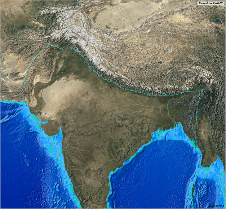
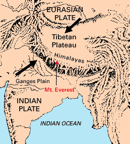
4. Describe how plate boundary movement can form mountain ranges and new ocean floor
Part 3: Volcanoes, Earthquakes, and plates
Activity 5: Volcanoes & Earthquakes around the world Volcanoes:

A volcano is a rupture in the crust of a planetary-mass object, such as Earth, that allows hot lava, volcanic ash, and gases to escape from a magma chamber below the surface. Volcanoes are generally found where tectonic plates are diverging or converging, and most are found underwater. Volcanoes release massive amounts of CO2 and liquid rock, known as lava when it reaches the surface.
Erupting volcanoes can pose many hazards, not only in the immediate vicinity of the eruption. One such hazard is that volcanic ash can be a threat to aircraft, in particular those with jet engines where ash particles can be melted by the high operating temperature; the melted particles then adhere to the turbine blades and alter their shape, disrupting the operation of the turbine. Large eruptions can affect temperature as ash and droplets of sulfuric acid obscure the sun and cool the Earth's lower atmosphere (or troposphere); however, they also absorb heat radiated from the Earth, thereby warming the upper atmosphere (or stratosphere). Historically, volcanic winters have caused catastrophic famines.
An earthquake is what happens when two blocks of the earth suddenly slip past one another. The surface where they slip is called the fault or fault plane. The location below the earth’s surface where the earthquake starts is called the hypocenter, and the location directly above it on the surface of the earth is called the epicenter.
What is the relationship between volcanoes, earthquakes, and tectonic plates?
C. Download each of your spreadsheets as .csv files. In google sheets select ‘file’, ‘download as’, ‘.csv - comma separated values’
D. Create a new google my map. Title it “Volcanoes & Earthquakes”. Select ‘base map’ and choose ‘satellite.’ Share with your table group
E. Select ‘Import’ and import your volcanoes .csv file. Select ‘latitude & Longitude’ and select ‘location’ as the column title. Once uploaded choose a unique icon and color for your pins
F. Repeat step E for your earthquakes .csv file.
1. Identify and describe any patterns you see between the locations of volcanoes and earthquakes on earth
2. Predict what could cause this pattern
3. Examine this map of earth's tectonic plates and compare it to the map you have created. Is there any relationship between plate boundaries, earthquakes, and volcanoes? Explain your answer
4. Examine this map of earth's subduction zones (what is a subduction zone? Click here) and compare it to the map you have created. Is there any relationship subduction zones, earthquakes, and volcanoes? Explain your answer
5. Volcanoes have occurred during the entire history of planet earth. Describe how volcanoes can influence extinctions on earth. This article will help
Part 4: Extinction
Activity 6: Earth's major extinction events

What is extinction?
Extinction is the end of an organism or group of organisms by the death of every member of a species. Species that still exist are referred to as being extant.
 How normal is extinction?
Extinction is a natural process of evolution by natural selection. Selective pressures such as changes in the environment cause extinctions to occur every year at a rate of 1 to 5 species a year. This ‘normal’ rate of extinction is referred to as the background extinction rate.
The extinction of a large number of species at a rate greater than the background extinction rate is known as a mass extinction event. These events are typically caused by catastrophic events on earth. Thus far there have been 6 mass extinction events. Today you are currently living through the sixth great extinction event, the holocene or Anthropocene extinction.
- Examine each of the 6 major extinction events using this link to complete the table below. Click the hand with the white finger to access the information.

2. Describe the causes of mass extinction events
3. Did you notice in patterns between each extinction event? Explain your answer
4. With each extinction event many species remained extant (did not go extinct). What could explain, in evolutionary terms, why life has persisted through mass extinction events?
5. Examine the anthropocene by exploring this interactive. Describe THREE ways human activity is contributing to the current anthropocene extinction event.
CER Argument
Research Question: What evidence supports the theory of plate tectonics?
Claim:
Evidence:
Reasoning:
Subscribe to:
Posts (Atom)